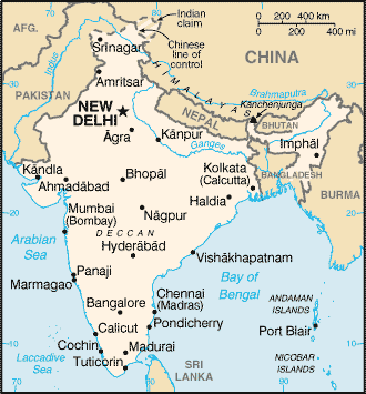
CIA INDIA
|
Background: |
The Indus Valley civilization, one of the oldest in the world, goes back at least 5,000 years. Aryan tribes from the northwest invaded about 1500 B.C.; their merger with the earlier inhabitants created the classical Indian culture. Arab incursions starting in the 8th century and Turkish in 12th were followed by European traders beginning in the late 15th century. By the 19th century, Britain had assumed political control of virtually all Indian lands. Nonviolent resistance to British colonialism under Mohandas GANDHI and Jawaharlal NEHRU led to independence in 1947. The subcontinent was divided into the secular state of India and the smaller Muslim state of Pakistan. A third war between the two countries in 1971 resulted in East Pakistan becoming the separate nation of Bangladesh. Fundamental concerns in India include the ongoing dispute with Pakistan over Kashmir, massive overpopulation, environmental degradation, extensive poverty, and ethnic and religious strife, all this despite impressive gains in economic investment and output. |
|
|
Area: |
total: 3,287,590 sq km |
||
|
Area - comparative: |
slightly more than one-third the size of the US |
||
|
Land boundaries: |
total: 14,103 km |
||
|
Coastline: |
7,000 km |
||
|
Maritime claims: |
contiguous zone: 24 NM |
||
|
Climate: |
varies from tropical monsoon in south to temperate in north |
||
|
Terrain: |
upland plain (Deccan Plateau) in south, flat to rolling plain along the Ganges, deserts in west, Himalayas in north |
||
|
Elevation extremes: |
lowest point: Indian Ocean
0 m |
||
|
Natural resources: |
coal (fourth-largest reserves in the world), iron ore, manganese, mica, bauxite, titanium ore, chromite, natural gas, diamonds, petroleum, limestone, arable land |
||
|
Land use: |
arable land: 54.35% |
||
|
Irrigated land: |
590,000 sq km (1998 est.) |
||
|
Natural hazards: |
droughts; flash floods, as well as widespread and destructive flooding from monsoonal rains; severe thunderstorms; earthquakes |
||
|
Environment - current issues: |
deforestation; soil erosion; overgrazing; desertification; air pollution from industrial effluents and vehicle emissions; water pollution from raw sewage and runoff of agricultural pesticides; tap water is not potable throughout the country; huge and growing population is overstraining natural resources |
||
|
|
People |
India |
|
Population: |
1,045,845,226 (July 2002 est.) |
||||
|
Age structure: |
0-14 years: 32.7% (male
175,858,386; female 165,724,901) |
||||
|
Population growth rate: |
1.51% (2002 est.) |
||||
|
Birth rate: |
23.79 births/1,000 population (2002 est.) |
||||
|
Death rate: |
8.62 deaths/1,000 population (2002 est.) |
||||
|
Net migration rate: |
-0.07 migrant(s)/1,000 population (2002 est.) |
||||
|
Sex ratio: |
at birth: 1.05
male(s)/female |
||||
|
Infant mortality rate: |
61.47 deaths/1,000 live births (2002 est.) |
||||
|
Life expectancy at birth: |
total population: 63.23 years |
||||
|
Total fertility rate: |
2.98 children born/woman (2002 est.) |
||||
|
HIV/AIDS - adult prevalence rate: |
0.7% (1999 est.) |
||||
|
HIV/AIDS - people living with HIV/AIDS: |
3.7 million (1999 est.) |
||||
|
HIV/AIDS - deaths: |
310,000 (1999 est.) |
||||
|
Nationality: |
noun: Indian(s) |
||||
|
Ethnic groups: |
Indo-Aryan 72%, Dravidian 25%, Mongoloid and other 3% (2000) |
||||
|
Religions: |
Hindu 81.3%, Muslim 12%, Christian 2.3%, Sikh 1.9%, other groups including Buddhist, Jain, Parsi 2.5% (2000) |
||||
|
Languages: |
English enjoys associate status but is the most important language for national, political, and commercial communication; Hindi is the national language and primary tongue of 30% of the people; there are 14 other official languages: Bengali, Telugu, Marathi, Tamil, Urdu, Gujarati, Malayalam, Kannada, Oriya, Punjabi, Assamese, Kashmiri, Sindhi, and Sanskrit; Hindustani is a popular variant of Hindi/Urdu spoken widely throughout northern India but is not an official language |
||||
|
Literacy: |
definition: age 15 and
over can read and write |
||||
|
Economy |
India |
|
|||
|
Economy - overview: |
India's economy encompasses traditional village farming, modern agriculture, handicrafts, a wide range of modern industries, and a multitude of support services. Overpopulation severely handicaps the economy and about a quarter of the population is too poor to be able to afford an adequate diet. Government controls have been reduced on imports and foreign investment, and privatization of domestic output has proceeded slowly. The economy has posted an excellent average growth rate of 6% since 1990, reducing poverty by about 10 percentage points. India has large numbers of well-educated people skilled in the English language; India is a major exporter of software services and software workers. The poor monsoon of mid-2002 has reduced agricultural output substantially. |
||||
|
GDP: |
purchasing power parity - $2.66 trillion (2002 est.) |
||||
|
GDP - real growth rate: |
4% (2002 est.) |
||||
|
GDP - per capita: |
purchasing power parity - $2,540 (2002 est.) |
||||
|
GDP - composition by sector: |
agriculture: 25% |
||||
|
Population below poverty line: |
25% (2002 est.) |
||||
|
Household income or consumption by percentage share: |
lowest 10%: 4% |
||||
|
Distribution of family income - Gini index: |
38 (1997) |
||||
|
Inflation rate (consumer prices): |
5% (2002 est.) |
||||
|
Labor force: |
406 million (1999) |
||||
|
Labor force - by occupation: |
agriculture 60%, services 23%, industry 17% (1999) |
||||
|
Unemployment rate: |
9% (2002) |
||||
|
Budget: |
revenues: $48.3
billion |
||||
|
Industries: |
textiles, chemicals, food processing, steel, transportation equipment, cement, mining, petroleum, machinery, software |
||||
|
Industrial production growth rate: |
5% (2002 est.) |
||||
|
Electricity - production: |
547.12 billion kWh (FY 2000-01, utilities only) (2000) |
||||
|
Electricity - production by source: |
fossil fuel: 83% |
||||
|
Electricity - consumption: |
509.89 billion kWh (2000) |
||||
|
Electricity - exports: |
321 million kWh (2000) |
||||
|
Electricity - imports: |
1.385 billion kWh (2000) |
||||
|
Agriculture - products: |
rice, wheat, oilseed, cotton, jute, tea, sugarcane, potatoes; cattle, water buffalo, sheep, goats, poultry; fish |
||||
|
Exports: |
$44.5 billion (f.o.b., 2001) |
||||
|
Exports - commodities: |
textile goods, gems and jewelry, engineering goods, chemicals, leather manufactures |
||||
|
Exports - partners: |
US 22.8%, Hong Kong 5.8%, Japan 5.3%, UK 5.3%, Germany 4.6% (2000) |
||||
|
Imports: |
$53.8 billion (f.o.b., 2001) |
||||
|
Imports - commodities: |
crude oil, machinery, gems, fertilizer, chemicals |
||||
|
Imports - partners: |
Benelux 8.5%, US 8%, UK 6.2%, Japan 5.7%, Saudi Arabia 4.6% (2000) |
||||
|
Debt - external: |
$100.3 billion (end-March 2001) |
||||
|
Economic aid - recipient: |
$2.9 billion (FY98/99) |
||||
|
Currency: |
Indian rupee (INR) |
||||
|
Currency code: |
INR |
||||
|
Exchange rates: |
Indian rupees per US dollar - 48.336 (January 2002), 47.186 (2001), 44.942 (2000), 43.055 (1999), 41.259 (1998), 36.313 (1997) |
||||
|
Fiscal year: |
1 April - 31 March |
||||
|
Communications |
India |
|
|||
|
Telephones - main lines in use: |
27.7 million (October 2000) |
|||||
|
Telephones - mobile cellular: |
2.93 million (November 2000) |
|||||
|
Telephone system: |
general assessment: mediocre
service; local and long distance service provided throughout all regions of
the country, with services primarily concentrated in the urban areas; major
objective is to continue to expand and modernize long-distance network to
keep pace with rapidly growing number of local subscriber lines; steady
improvement is taking place with the recent admission of private and
private-public investors, but, with telephone density at about two for each
100 persons and a waiting list of over 2 million, demand for main line
telephone service will not be satisfied for a very long time |
|||||
|
Radio broadcast stations: |
AM 153, FM 91, shortwave 68 (1998) |
|||||
|
Radios: |
116 million (1997) |
|||||
|
Television broadcast stations: |
562 (of which 82 stations have 1 kW or greater power and 480 stations have less than 1 kW of power) (1997) |
|||||
|
Televisions: |
63 million (1997) |
|||||
|
Internet country code: |
.in |
|||||
|
Internet Service Providers (ISPs): |
43 (2000) |
|||||
|
Internet users: |
7 million (2002) |
|||||
|
|
Transportation |
India |
|
|||
|
Railways: |
total: 63,693 km (13,771 km electrified)
|
||
|
Highways: |
total: 3,319,644 km |
||
|
Waterways: |
16,180 km |
||
|
Pipelines: |
crude oil 3,005 km; petroleum products 2,687 km; natural gas 1,700 km (1995) |
||
|
Ports and harbors: |
Chennai (Madras), Cochin, Jawaharal Nehru, Kandla, Kolkata (Calcutta), Mumbai (Bombay), Vishakhapatnam |
||
|
Merchant marine: |
total: 319 ships (1,000 GRT or over)
totaling 6,325,284 GRT/10,581,459 DWT |
||
|
Airports: |
335 (2001) |
||
|
Airports - with paved runways: |
total: 234 |
||
|
Airports - with unpaved runways: |
total: 101 |
||
|
Heliports: |
18 (2001) |
||
|
Transnational Issues |
India |
|
||
|
Disputes - international: |
discussions with Bangladesh remain stalled to delimit a small section of river boundary, demarcate and fence off the entire boundary, exchange 162 minuscule enclaves, and allocate divided villages while skirmishes, illegal trafficking, and violence along the border continue; Bangladesh has protested India's attempts to fence off high traffic sections of the porous boundary; dispute with Bangladesh over New Moore/South Talpatty Island in the Bay of Bengal; much of the rugged, militarized boundary with China is in dispute but talks to resolve the least contested middle sector resumed in 2001; with Pakistan, armed stand-off over the status and sovereignty of Kashmir continues; dispute with Pakistan over terminus of Rann of Kutch prevents extension of a maritime boundary; water-sharing problems with Pakistan persist over the Indus River (Wular Barrage); Joint Border Committee formed with Nepal in 2001 is intended to resolve 53 disputed sections of boundary covering an area of 720 sq km |
|
Illicit drugs: |
world's largest producer of licit opium for the pharmaceutical trade, but an undetermined quantity of opium is diverted to illicit international drug markets; transit point for illicit narcotics produced in neighboring countries; illicit producer of methaqualone; vulnerable to narcotics money laundering through the hawala system |
This page was last updated on 13 February 2003